Contact David F. Ryder III
Schedule A Showing
Request more information
- Home
- Property Search
- Search results
- 11425 Us Highway 301, OXFORD, FL 34484
- MLS#: G5077584 ( Land )
- Street Address: 11425 Us Highway 301
- Viewed: 132
- Price: $4,500,000
- Price sqft: $0
- Waterfront: No
- Year Built: Not Available
- Bldg sqft: 0
- Days On Market: 435
- Additional Information
- Geolocation: 28.9218 / -82.035
- County: SUMTER
- City: OXFORD
- Zipcode: 34484
- Provided by: OXFORD LAND COMPANY
- Contact: Reginald Caruthers
- 352-748-1182
- DMCA Notice
-
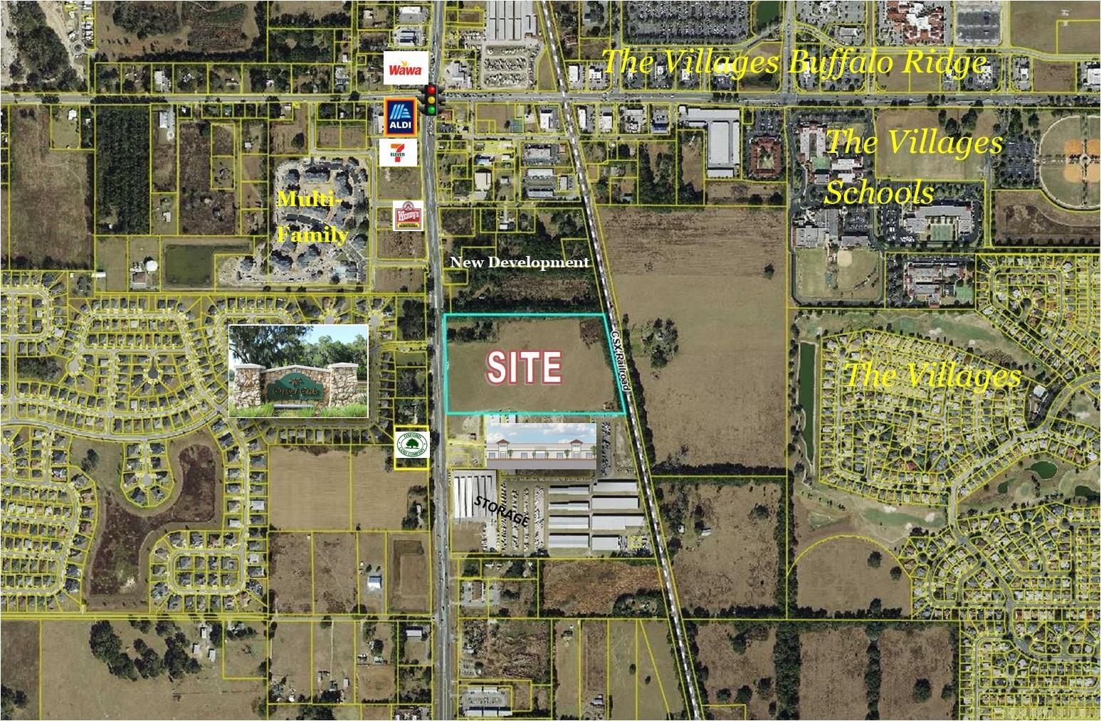
DescriptionImpressive 23+/ acres right in Oxford, fronting US 301. CH zoning on the front portion 400' deep, then A10C zoning in the rear. Much potential for housing and/or other type development. Wildwood water and sewer hookup is on the property but annexation is still needed. The utility connections were brought under US 301 from Oxford Oaks to accommodate the Preston Place business/storage complex that is contiguous to this property, and can be utilized for this site. The immediate neighborhood includes Oxford Oaks single family neighborhood, Preston Place business park, Multi family, office, and retail. Excellent visibility with right in/right out access. There is a home, small barn, and fencing on the property. DIVISIONS AVAILABLE.
All
Similar
Property Features
Home Owners Association Fee
- 0.00
Carport Spaces
- 0.00
Close Date
- 0000-00-00
Country
- US
Covered Spaces
- 0.00
Current Use
- Residential
Garage Spaces
- 0.00
Insurance Expense
- 0.00
Legal Description
- BEG 460 FT N OF SW COR RUN N 1872.15 FT THENCE E TO W/LY R/W OF SAL RR S 12 DEG 02 MIN 45 SEC E ALONG SAID RW 1916.45 FT W 1647.7 FT TO POB LESS COMM AT NW COR OF SW 1/4 OF SW 1/4 RUN S 175 FT TO POB RUN E 450 FT S 729.25 FT W 450 FT N 729.98 FT TO P OB LESS COMM AT SW COR RUN N 00 DEG 02'46"E 460 FT S 89 DEG 42'56"E 450 FT TO POB N 00 DEG 02'46"E 40 FT S 89 DEG 42'56"E 3.62 FT N 00 DEG 16'08"W 585.02 FT S 89 DEG 42'56"E 1063.01 FT TO W/LY R/W OF CSX RR S 12 DEG 01'52"E 639.72 FT N 89 DEG 42'56" W 1197.26 FT TO POB AND LESS BEG AT SW COR RUN N 00 DEG 02'46"E 1149.89 FT S 89 DEG 50'53"E 48.96 FT TO E/LY R/W US HWY 301 AND POB CONT S 89 DEG 50'53"E 156.66 FT N 00 DEG 21'31"E 108.48 FT N 89 DEG 38'29"W 159.85 FT S 01 DEG 19'10"E 109.09 FT
Living Area
- 0.00
Area Major
- 34484 - Oxford
Net Operating Income
- 0.00
Open Parking Spaces
- 0.00
Other Expense
- 0.00
Parcel Number
- D17-052
Property Type
- Land
Sewer
- Septic Tank
Tax Year
- 2023
Township
- 18S
Utilities
- BB/HS Internet Available
- Cable Available
- Cable Connected
- Electricity Available
- Phone Available
- Sewer Available
- Sewer Nearby
- Water Available
- Water Nearby
Views
- 132
Virtual Tour Url
- https://www.propertypanorama.com/instaview/stellar/G5077584
Water Source
- Well
Zoning Code
- CH
- A10C

Listing Data ©2025 Greater Fort Lauderdale REALTORS®
Listings provided courtesy of The Hernando County Association of Realtors MLS.
Listing Data ©2025 REALTOR® Association of Citrus County
Listing Data ©2025 Royal Palm Coast Realtor® Association
The information provided by this website is for the personal, non-commercial use of consumers and may not be used for any purpose other than to identify prospective properties consumers may be interested in purchasing.Display of MLS data is usually deemed reliable but is NOT guaranteed accurate.
Datafeed Last updated on April 2, 2025 @ 12:00 am
©2006-2025 brokerIDXsites.com - https://brokerIDXsites.com